Thank you for your patience while we retrieve your images.
Visitors 27


61 of 115 photos
Thumbnails
Info
Categories & Keywords

Category:Scenic
Subcategory:Deserts
Subcategory Detail:
Keywords:Canyonlands, Island in the Sky, La Sal, Mesa Arch, Southwest, UT, Utah, american, arch, bright, close up, day, desert, detail, landscape, mountains, national park, nature, photography, red rock, rock formation, texture
Photo Info

Dimensions4000 x 2670
Original file size7.44 MB
Image typeJPEG
Color spacesRGB
Date taken22-Jun-13 17:53
Date modified5-Oct-13 21:42
Shooting Conditions

Camera makeNIKON CORPORATION
Camera modelNIKON D600
Focal length70 mm
Focal length (35mm)70 mm
Max lens aperturef/4.4
Exposure1/15 at f/22
FlashNot fired, compulsory mode
Exposure bias0 EV
Exposure modeAuto
Exposure prog.Aperture priority
ISO speedISO 100
Metering modePattern
Digital zoom1x
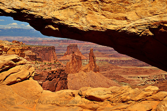
Daytime look through the Mesa Arch, Island in the Sky, Canyonlands National Park, Utah (UT).

Look through the Mesa Arch

Looking down through the Mesa Arch in the Island in the Sky District of the Canyonlands National Park you can see more rock formations in the canyon below as well as La Sal Mountains in the distance on the left.

This is probably one of the better known and more photographed areas of the park as the arch is a popular sunrise destination for photographers. This photograph offers a different view with the arch itself being generously lit. It provides a close look at the details and textures of the rock, as well as the whole formations further down. La Sal mountains add a hint of greenery to an otherwise arid red rock landscape, and their white rocky peaks hint at how geologically rich this area is and how much time one could spend learning about it all as well as visiting, photographing, and enjoying!

Canyonlands National Park, located in the southeastern corner of Utah, is spread over a very large area and is divided into districts, each offering a whole different experience. Island in the Sky in the park's north is high above the canyons and offers expansive scenic views of the land below. It is squeezed between two rivers, the Green River to the west and the Colorado River to the east. The other districts of the park are Needles, Maze, Horseshoe Canyon, Rivers.

A natural arch is a rock exposure that has a hole completely through it formed by the natural, selective removal of rock, leaving a relatively intact frame. A natural bridge is a type of natural arch, generally over a current or past body of water. Other definitions also allow for calling something a bridge simply because it looks like one. And then there are also natural windows and tunnels, used without clear definitions or with any consistency.