
Welcome to my blog! Read about photography, film photography in 35mm, medium, and large formats, pinhole photography, about darkroom printing, alternative photographic processes, and more. Thank you for visiting!
The Murals at the Mall at Greece Ridge, Rochester, NY
 Shea's in the Rain MuralThe Mall at Greece Ridge, Rochester, NY.
 In September 2013 two of my photographs went on display as large panoramic murals. The PR company in charge of finding about 30 murals for a newly renovated wing of The Mall at Greece Ridge (The State Street Wing) in Rochester, NY selected them to be displayed at approximately 30 feet x 11 feet.
While my photos did make it to several publications, offline and online, I have not had them published at this size yet. It was exciting to be selected and to work with the PR company on making it happen!
The whole thing did not really fully sink in though until I found time to take a drive to Rochester, locate the right portion of the mall, and see the murals with my own eyes! It was a special moment for me and it all felt so worth it!
 Boating Action by the Lighthouse MuralThe Mall at Greece Ridge, Rochester, NY.
The first of the two murals, Shea's in the Rain, is displayed above a storefront at 30' x 11'. The second mural, Boating by the Lighthouse, was placed right next to the Shea's one. That is displayed over the mall corridor at 50' x 13'.
One problem was capturing the moment with my cell phone. How do you fit 30 and 50 feet in a cell phone? And later, how do you display it on a web site as a tiny image and do it justice?
Well, that is simple - you don't! So here are just couple individual cell phone camera snaps and one showing both murals in one.
 Shea's Buffalo and Boating by the LighthouseThe Mall at Greece Ridge, Rochester, NY.
As special as the moment felt a look around also made the whole experience very humbling. The other 28 murals were all excellent, great images representing New York state so well! I walked around the mall's northeast wing and paused in front of each of the murals. Hats down to all included photographers!
On that note, I also wanted to say a big thank you to all of you reading my blog here, visiting my gallery, or following my photo streams on Flickr or G+. The encouragement I receive through the online communities keeps me pushing forward and challenging myself to improve.
Thank you!
Bird Island Pier Re-opened!
 NIagara River under Moon and VenusBird Island Pier is open again!
In one of my summer posts I lamented what a shame it was that the Bird Island Pier remained closed beyond Piece Bridge. And a shame it surely was. Now the irony was in the timing.
A few weeks later I was looking around the Internet to find out more about the future fate of the pier. It did not take me long and I stumbled upon an article in Buffalo News proclaiming the pier would re-open on August 12, 2013, after three long years of being cut short. That was in the past at that point, a day after my last visit.
So back I went to enjoy this wonderful walk in Buffalo. Walking the pier between Black Rock Canal and the mighty Niagara River is always a great and refreshing experience. A fresh breeze, the sound of the river, wonderful sunset views, and if you walk far enough, great views of the city of Buffalo.
This evening, I arrived too late to walk the whole length and still have some color left in the sky but it was enough to celebrate the re-opening. As I walked past the point of closure under the Peace Bridge it really felt special. I only continued another 10 minutes or so and set up to document the regained access.
 Bird Island Pier under Crescent Moon and VenusSunset, moon, Venus, Bird Island Pier, Black Rock Canal, Niagara River, Lake Erie, all in One!
And the added bonus provided by nature's generosity? The crescent moon was to the southwest allowing me to get photos of it along with the sunset colors, as well as aligned with the pier! And as if that was not enough, Venus was accompanying moon this evening and posed for my photographs too! What an evening!
To close things off, I looked back a few times on my walk back and noticed that both the moon and Venus descended closer to the horizon to fit nicely under Peace Bridge. While the color in the sky was gone by that time, I could not resist this unique take on a photo I've taken so many times!
So what is left? Well, I still have not walked the full length of the pier since it reopened and will need to fix that soon before something prompts authorities to close it again.
 Peace Bridge, Moon, and VenusA special occasion take on Peace Bridge at Night
Have fun at your favorite places!
Equipment used: Nikon D600, Nikon 24-85mm Nikkor Lens, Think Tank Speed Demon Waist Pack, Petzl Zipka Plus 2 Headlamp (always in the bag just in case), SanDisk Extreme 32GB SD Cards, Nikon Capture NX2
Using my links to buy your equipment keeps me going and costs you nothing. You can also use the Amazon search box in bottom left for anything not mentioned here. Thank you very much, I really appreciate it!
The Seasons They Are a-Changin'
 Scouting Hog's BackMid-day light over Letchworth's Hogs Back
The daylight savings time is gone, it's 29°F and forecast 22°F for the morning. There are still some remaining colors up on trees, mostly yellow and some orange. The frosts came early in September but then it warmed up and the color progression slowed down markedly. As such, reds were in short supply this fall season. However, the yellows and oranges were beautiful too and the fall season was another unique show of nature's artful creations.
I have so many photos to share from this fall season but am not sure my timing will be great. I like to keep my posts somewhat timely, with the occasional break down of a late post I did not get to sooner. Posting wild colors when it's all white around may seem odd. Let's see, maybe the winter blanket will hold off for a few more days, or even weeks.
The Letchworth State Park is a Western and Central New York state classic, especially in the fall with all of its deciduous trees showing off their autumn coats. 2013 was a good year for me and Letchworth and I made it to the park quite a few times to witness sunrises, warm summer days, and a sunset or two. I made it to the balloon festival during the Memorial Day weekend. I also managed to get a little bit off the beaten path and explored a few new trails. On each of these visits I also always vividly remembered my beautiful foggy experience from last year!
This was a hiking day, hoping to go to the Papermill Falls, which I am yet to see. But that plan was thwarted early. There was a water main break at the trailhead, which in turn was closed and bulldozers were the only trail blazers at that time. Instead of heading down Trail #19 we hiked the nearby Trail #18, just across the Silver Lake Outlet gorge. While so close, its also so very far. This branch of a gorge is very deep and possibly even more impressive than the Genesee River gorge itself. Trail #18 dead ends on a spur with a straight down drop off.
After some initial delays and the hike the time reserved for exploration has passed and it was time to leave the park behind. Before heading for the exit, we stopped at the Hog's Back though. I had not been to the northern part of the park in a while and wanted to scout sunrise possibilities there. I am certainly glad we stopped! It was the final motivation I needed to set the alarm and head out.
 Cloudy Daybreak at Hog's BackLetchworth colors on show before sunrise
The Hog's Back of Letchworth before Autumn Sunrise
While nature had different plans than I and obstructed this morning's sunrise it gave me something possibly even better. The dark ominous clouds over the fall color show made for heck of a backdrop!
As always, plan, but welcome the unexpected, … and most of all, have fun!
Sources:
Equipment used:
- Nikon D600
- Nikon 24-85mm Nikkor Lens
- Induro Carbon Fiber 4-section Tripod (CT014) (my travel tripod; its four sections give it smaller collapsed size and it's also lighter than my standard workhorse tripod. It has been through deserts and oceans and is still going strong after 4 years)
- Manfrotto ball head (496RC2)
- Cokin graduated ND4 filter (last photo)
- Cokin P Holder with a 72 mm Adapter (last photo)
- Think Tank Speed Demon Waist Pack, Petzl Zipka Plus 2 Headlamp (always in the bag just in case), SanDisk Extreme 32GB SD Cards
- Exposure delay mode of 2 seconds, no remote release
- Nikon Capture NX2
Using my links to buy your equipment keeps me going and costs you nothing. You can also use the Amazon search box in bottom left for anything not mentioned here. Thank you very much, I really appreciate it!
Road Trip: White Pole Road
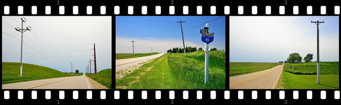 White Pole Road, IowaTravel the history through the towns of Adair, Casey, Menlo, Stuart and Dexter.
 White Pole Road, IowaTravel the history through the towns of Adair, Casey, Menlo, Stuart and Dexter.
Iowa became the 29th state to join the United States on December 28, 1846. The capital city is Des Moines. The highest point is Hawkeye Point at 1,670 feet.
Road Trip 2013 - Day 3 - June 13 - Iowa - Stop 2 (Previous road trip 2013 posts: Indiana Dunes, De Immigrant, Amana Colonies, Des Moines, Madison County Roads, Bridges of Madison County)
There are many iconic roads in the United States that all experienced a similar sequence of events from the initial efforts to build them through a period of high popularity and fame to an Interstate induced decline. Roads like Route 66 and the Lincoln Highway come to mind. However, these national highways are just the tip of the iceberg. There are other roads with state significance and the White Pole Road is certainly one of them in the state of Iowa.
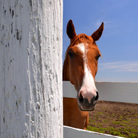 Curious HorseWhite Pole Road, Stuart, Iowa.
The White Pole Road was designated in 1910 to improve Iowa's reputation for unpassable roads. It was not funded by state but maintained by people to insure access to their towns to get travelers and customers. It stretched from Davenport, IA to Council Bluffs, IA. Its poles were painted white and the road was advertised as the "Great White Way" people were encouraged to travel.
In 1913 the road became Iowa's first State Route. Since then, it was renumbered several times and bounced between the state and federal highway systems. 1965 did not bring good news to the road nor to the communities it was passing through. The I-80 significantly diminished its popularity.
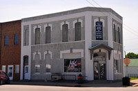 Bonnie & Clyde Robbery SiteFirst National Bank
In 2003 a 26-mile section was given to the counties (Rte 925) and officially renamed White Pole Road. Once again it's up to the people to maintain the road and grow their communities. It connects the towns of Adair, Casey, Menlo, Stuart and Dexter (between mile markers 76 and 100). It's very close to I-80 so get a break from your high speed chase and the constant rush, slow down, and take a detour through history. I guarantee, you will see and learn more than on the Interstate!
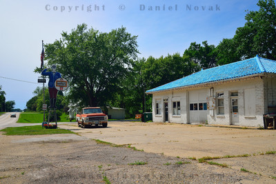 Friendly Gas Station ManMenlo, Iowa (IA)
Hit The White Pole Road web site and print yourself a map and a list of attractions and get on the road. Even better, once in the area, stop by a Casey's General Store or a Kum & Go Convenience Store in the five-town area to get your official Audio Tour CD for your self-guided tour of the attractions. Still need more motivation? Turn your volume up and take a listen to the tour theme song.
This section of the road could make for an all-day fun, however, for us this was only one of the day's planned activities. We drove along, had fun watching out of the window, and picked at least one or two places of interest around each town. I'm listing some of our favorites below but if you're going to hit this road, please, refer to the sources listed here for additional details.
It was also nice to see some sense of humor on the towns' welcome boards. Each of them adds a tagline along its name.
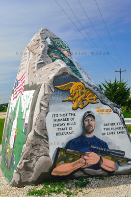 Freedom Rock®White Pole Road, Menlo, Iowa
Dexter, the Original One Horse Town:
Bonnie (Parker) & Clyde (Barrow) Shootout Site at the former Dexfield Park, the location of a bloody Barrow Gang fight against the local posse in 1933. The gang camped out here after their painful gateway from the Red Crown Tavern in Platte City, Missouri. However, their cover did not last long and another shootout occurred just a few days later. Bonnie & Clyde escaped but Blanche and Buck were not so lucky. Bonnie & Clyde's future was only about a year long, eventually hunted down by Frank Hamer assisted by a great negative publicity of the gang.
Drew’s Chocolates, started in 1927 and is still hand dipping chocolates and making them to the original recipes in the same location.
Stuart, Home of 1700 Good Eggs and a Few Stinkers:
A brick train depot built in 1879 with material from a demolished Rock Island Railroad Depot in Illinois.
Bonnie & Clyde Bank Robbery Site (former site of the First National Bank of Stuart) that Bonnie & Clyde held up a month before they were shot dead. It recently housed the Stuart Police Department. Right now, it is a salon.
The Curious Horse. This one is added by me and you will not find it on the attraction list. But if you or your kids like horses be on the lookout!
Menlo, a Town of Few & Friend of All:
Friendly Gas Station Man commissioned by the Kalbach Oil Company in 1934.
The Freedom Rock®, an approximately 60-ton boulder that serves as Ray “Bubba” Sorensen’s canvas repainted every year with patriotic images to say Thank You to Veterans (photograph included with the permission from Sorensen Studios). The annual one rock project (in its 15th year) recently transformed into a multi-year project to put a smaller version into every county in Iowa (57 counties have already booked one!): The Freedom Rock Tour®, which has just wrapped up its first year by painting a rock in 10 more counties!
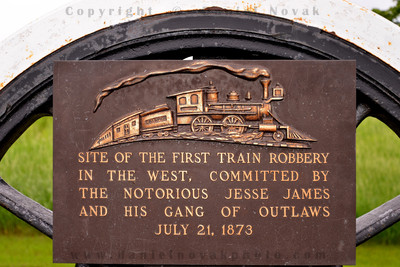 Jesse James Train Robbery SiteWorld’s First Robbery of a Moving Train
Casey, Antique Country:
Slayton Rock was what Robert Slayton dug out while looking for a landscaping accent rock. Only a tiny portion was sticking out of their neighbor's field. It turned out to be 14" high and about 250 - 300 tons! They ended up moving it over one and a half miles involving almost 100 people and some significant machinery.
Adair, Home of the Bombers:
Smiling yellow water tower visible from Interstate I-80 and advertising the happiest town on Earth.
Adair Viaduct over the Rock Island rail line opened to public in 1924 and remains in use to this day. Unlike most bridges that focused on function only the Adair Viaduct combines functionality with aesthetics with its decorative rails and towers.
Jesse James Historical Marker, the site of the world’s first robbery of a moving train on July 21, 1873. It was also the first train robbery west of Mississippi River. While the train was not carrying the expected gold the robbery was not a complete failure and Jesse, his brother Frank, and the rest of the gang left with some decent cash. Jesse James had 9 years to go before being betrayed and killed.
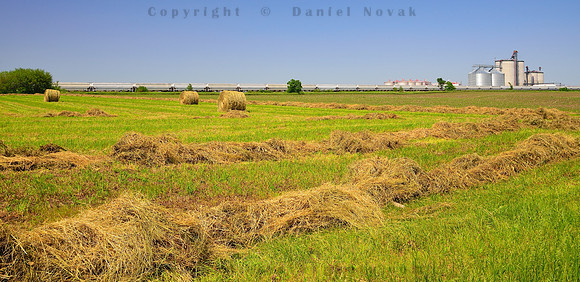 Rural IowaSoak in the Midwest while driving through Adair, Casey, Menlo, Stuart and Dexter.
Despite having thousands of planned miles ahead of us this was such a treat! You can slow down, roll down the windows, and look around and soak in the Midwest rural landscape. That alone makes it worth a while. And then of course, all of the above is a great bonus!
So turn on that right blinker of yours, get off the Interstate, relax and have fun!
Sources:
- The White Pole Road (Map and Attractions)
- Bonnie and Clyde on Wikipedia, the Barrow Gang on Wikipedia, Bad Day for Buck and Blanche
- The Freedom Rock®
- Jasse James on Wikipedia
- History of Stuart, Iowa
- The Lincoln Highway
- Route 66
Equipment used:
- Nikon D600
- Nikon 24-85mm Nikkor Lens
- Promaster 72mm Circular Polarizing Filter
- Think Tank Speed Demon Waist Pack, Petzl Zipka Plus 2 Headlamp (always in the bag just in case), SanDisk Extreme 32GB SD Cards
- Nikon Capture NX2
Using my links to buy your equipment keeps me going and costs you nothing. You can also use the Amazon search box in bottom left for anything not mentioned here. Thank you very much, I really appreciate it!
Canyon Lake - Changing Tastes, Different Conversion and Processing
 Canyon LakeOriginal Processing
Here's a photo I took some years back while driving and exploring the beautiful scenic Apache Trail near Phoenix, Arizona. The whole scenic road offers so much and having a whole day reserved is definitely the best.
Anyway, I was going through my older landscapes the other day and came across this one. I wanted to add it to my landscape gallery and since it was in black and white it was also a candidate for my World Without Color Collection.
With a few years passing since taking the photo and doing the initial processing and black and white conversion, I guess my taste changed a little. While I still liked the photo I thought the rocks were a bit too contrasty and dark, and I felt a darker representation of the sky would better set off the distant peak, probably taking clues from the style Ansel Adams established with his black and white photography.
 Canyon LakeNewer processing, brighter, less contrasty, and with darker sky.
So I got working on the photo again, simulated a red filter to darken the sky, backed off on the original contrasty curves, and did some local dodging and burning. All in all, in not too long I transferred the image into a little different look you see in number two to the right below.
But then I had doubts when I put the original and the new one side by side. I liked the new one but maybe the difference from the original processing was too much? I posted the new version to Flickr, along with the original one, for feedback. Some people liked the new version, some the old, some recommended for a blended approach mostly due to the rocks appearing too bright or even washed out. So a day later, I was at it again trying to see if I could make something even better happen.
 Canyon LakeThe third version - darkest clouds, medium rock contrast.
The third photo you see here was where I wanted to stop. The darkest sky of them all, the distant peak standing out the most, the rocks not as bright as the second version but not as dark as the first, a photo based on my vision and the advice of many.
But was it the best one of them all? Maybe, maybe not, something did not feel right about it though and I almost liked number two better. However, number two had the whites very high. It looked fine on a calibrated monitor but not so much otherwise. So back I went again for the fourth edition with a clear goal compared to number three: to raise the midpoint of the rocks and avoid or reduce any steps that darkened the trees too much.
And that is what you see below in the large size and what I felt comfortable adding to my landscape gallery.
 Canyon LakeFourth and Final Processing Version.
Canyon Lake on Apache Trail, The Final Black and White Conversion and Processing
Am I done with this photo? For now. However, I am planning on having these printed out to compare them the old-fashioned way - on paper, as real photos, not just a bunch of pixels on a computer screen!
Do you have any comments? Please, share here by posting comments.
Thanks for reading along and have fun turning your visions into photos!