
- Home
- | Galleries ▼
- | Collections ▼
- | About ▼
- | Blog
- | Zines
- | Login
Road Trip: Moore, OK after the 2013 Tornado

Support this blog during this shopping season: Do you like my free content but are not ready to buy a photograph yet? Using my links (Amazon) to do your shopping helps me share more photographs and write the stories behind them. Thank you!
Oklahoma became the 46th state to join the United States on November 16, 1907. The capital city is Oklahoma City. The highest point is Black Mesa at 4,973 feet.
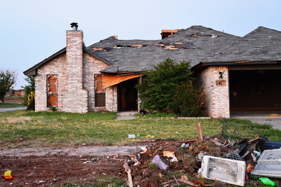 Survived the 2013 TornadoMoore, OK Tornado
 Road Trip 2013 - Day 16 - June 26 - Moore, OK after the 2013 Tornado (Previous 2013 Road Trip posts: Indiana Dunes, De Immigrant, Amana Colonies, Des Moines, Madison County Roads, Bridges of Madison County, White Pole Road, Great Platte River Road Archway Monument, Golden Spike Tower & Union Pacific's Bailey Rail Yard, Loveland Pass, The Resting Day at Powderhorn, Black Canyon of the Gunnison, Cimarron, Colorado National Monument, Fruita Rodeo, Grand Mesa, Arches National Park, Grand Junction, Grand Mesa Creek, Arches National Park Add-On, Canyonlands National Park, The Little Big Moments of Road Tripping, Mesa Verde National Park, Santa Fe, Santa Fe Train Depot, Pecos National Historical Park, Route 66 Part I, Santa Rosa, NM, Route 66 Part II, Santa Rosa, NM, Route 66 Part III, Tucumcari, Route 66 Part IV: Cadillac Ranch, Route 66 Part V: Bug Ranch), Route 66 Part VI: Conoco & Magnolia, Moore, OK after the 2013 Tornado
It was an intense experience. You can only be prepared for something like this so much. Despite all of the news coverage things become more real when you're standing on the spot yourself. Standing on the spot where a whole neighborhood stood just a month ago and now it's been turned into rubble.
The whole scene left behind the May 2013 twister in Moore, OK was really hard to take in. The way one could clearly tell the path was unsettling. A large path of devastation with clear and abrupt edges. One side of the street razed to the ground, the other with some damage but houses still standing. What a phenomenon!
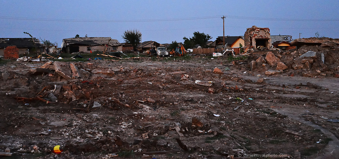 Tornado DestructionAfter the 2013 Moore, OK Tornado
It's still terrifying even four years later, and even more so as tornadoes and their severity seems to be more prevalent and more widespread outside of tornado alley, and now even close to home with the EF2 rolling through Orchard Park on July 20, 2017, mere 2 miles from home.
This post prompted me to read more about what happened four years ago now that a lot of the collected data has been processed. And also about the area and the human point of view. Just look at how many tornadoes have been recorded in the Moore, OK vicinity since 1890! I've listed some of that reading below in references.
A pause, a moment of silence.
References: Oklahoma on 50States.com - 2013 Moore tornado - Why Wasn't This Town Prepared When the Big Tornado Hit? - The Mercy of the Sky: The Story of a Tornado - Moore, Oklahoma Tornadoes (1890-Present) - Moore, Oklahoma, Tornado 3 Years Later: What Turned It Violent? - Moore bounces back after 2013 tornado - Black Mesa: Oklahoma’s high point on the high plains
Would you like to see more of my travel photographs? Visit the Travel Photography gallery or the On the Road photo collection. Please, let me know if you have any questions about any photo products offered, or not offered. Looking for a present? I also offer ready to hang solutions like canvas gallery wraps, prints on metal, and matted and framed ready to hang photographs.
Do you like my free content but are not ready to buy a photograph for your walls yet? Using my links to do your shopping helps me share more photographs and write the stories behind them. And it costs you nothing. You just need to start your shopping by clicking on an advertised product or use the Amazon search box in bottom left. It does not matter what you eventually buy as long as you start here. I truly appreciate each purchase, no matter how small. Thank you!
SaveSaveSaveSave